

Equipment & Software for Geophysical Surveys: Design, Manufacture, Support, Supply
Horin Geophysical Software - program for geological and geophysical data processing
Horin is a software package designed for complex processing, visualization and analysis of geophysical and geological data obtained during land, air and marine surveys. The program works with magnetic, gravity and electrical survey data and supports a wide range of tools for their interpretation, correction and graphical representation. The Horin interface is intuitive and easy to use. The program is equipped with built-in tools for data import and export, corrections for gravity and magnetic exploration, transformation (1D/2D) of potential fields, filtering, and 2D/3D visualization.
Horin application areas:
- Mineral prospecting and exploration
- Marine and airborne geophysics
- Hydrogeology and groundwater prospecting
- Engineering geophysical surveys
- Environmental monitoring
- Archaeology
- Scientific research
Data import and export
The Horin database supports importing common formats such as: ASCII, XYZ, Excel and Access, as well as exporting data to Surfer, Encom, ArcGIS ASCII formats, etc.
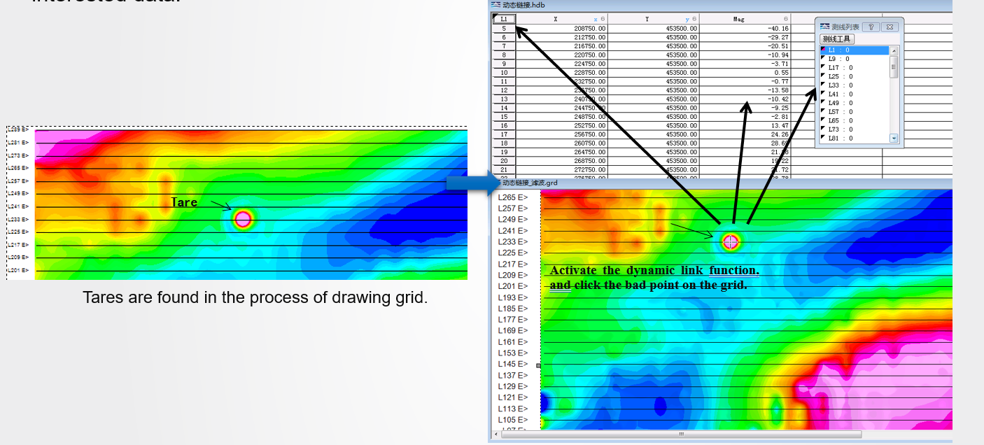
Quality Analysis and Quality Control – It includes a linkage function that connects the database with both the section and map views, enabling quick identification of tares or target points within large datasets and facilitating editing or deletion operations. The mobile survey carrier handles a significant volume of data, high workload, and is prone to errors. Horin software offers a user-friendly batch tare deletion feature, which significantly enhances work efficiency.
Database Tools – Horin® provides a comprehensive set of database matching tools, such as decimation, resampling, picking, interpolation, modification of abnormal property values, statistics, sorting, wiring, database calculator, histogram analysis, and database merging, among others. These tools streamline data organization and management.
Data Extraction and Matching – There are two efficient methods for extracting target data: 'Extract from Database' and 'Extract from Grid.
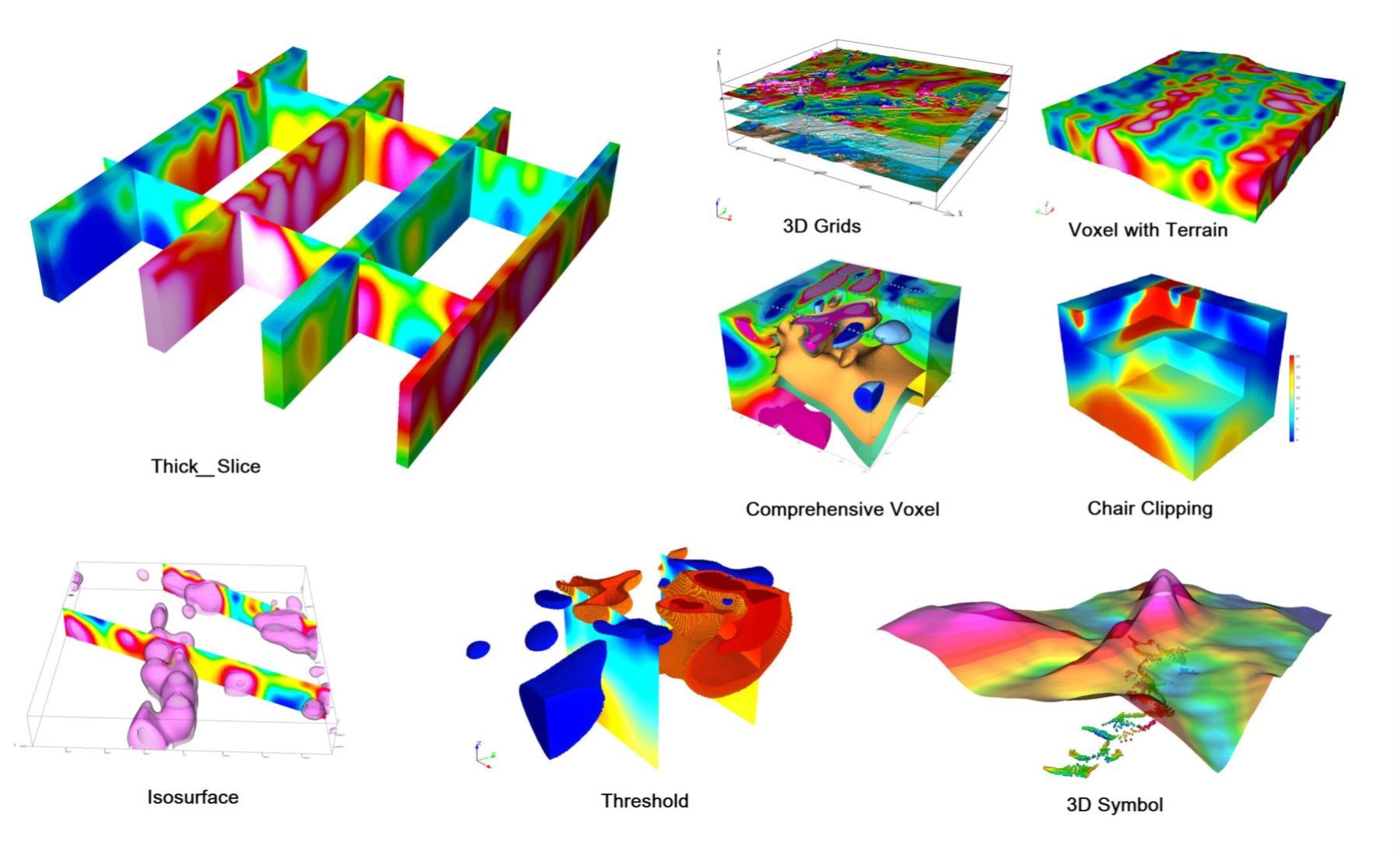
Grid and Grid Tools
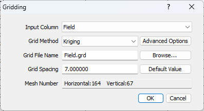
Gridding – It offers four grid generation techniques: bi-directional interpolation, inverse distance, nearest neighbor, and kriging. It comes with several color templates and three color mapping options, supports the inclusion of sunlight and shadows, and enables real-time preview. Experts can enhance their skills using advanced professional tools.
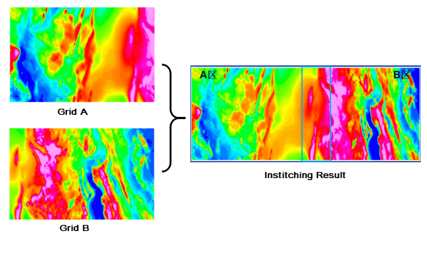
Grid Stitching – Horin automatically locates overlapping zones in various grids and seamlessly combines them through grid stitching.
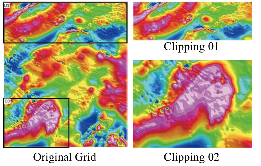
Grid Clipping – The program includes features that allow users to interactively define and extract the desired area from the grid.
Extract Profile Line from Grid – Users can interactively extract one or more profile lines from the grid, which are then saved in the Horin database.
Mapping System
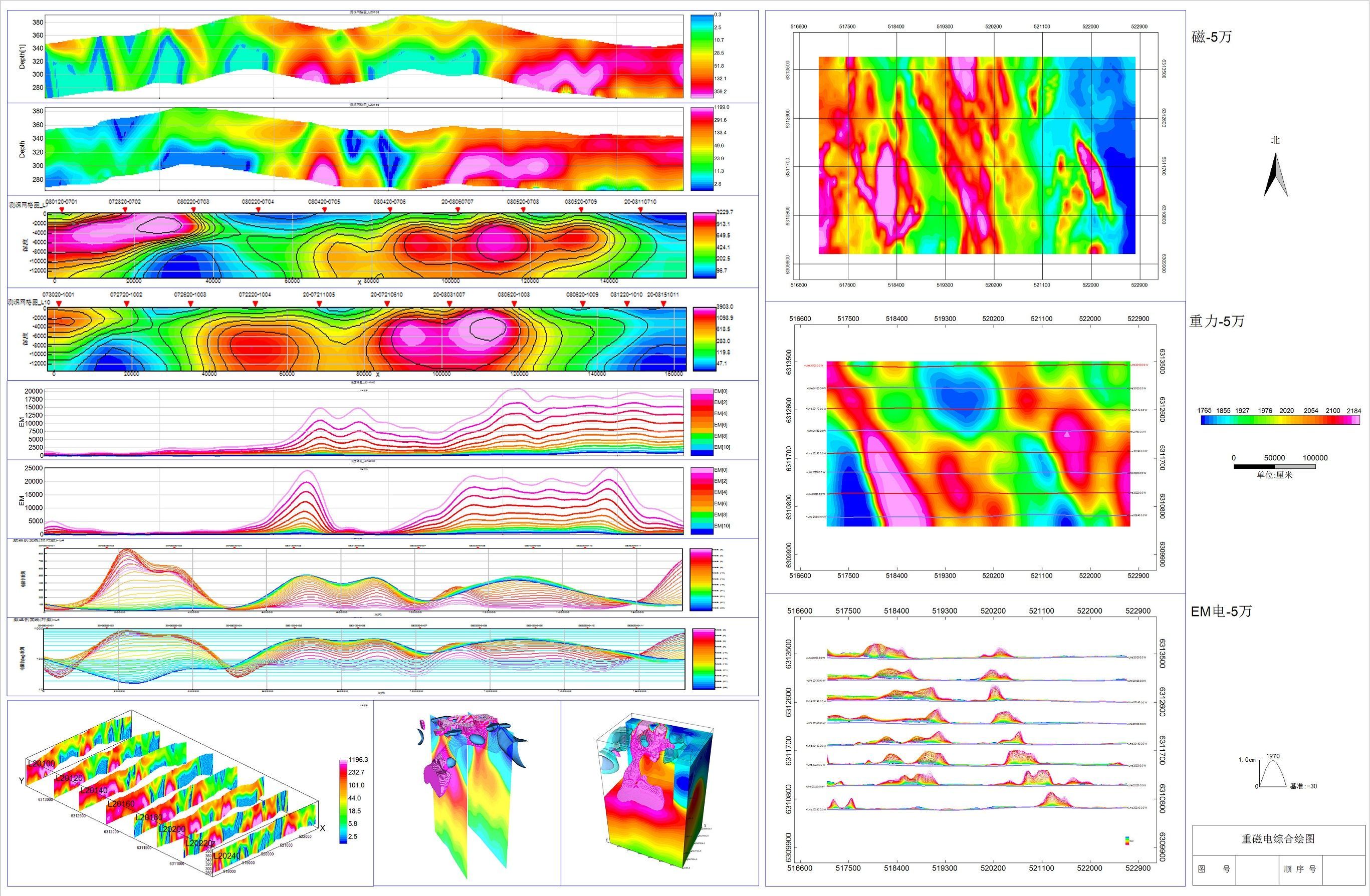
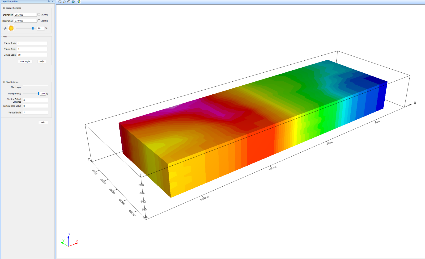
Horin® software allows for the creation of a wide range of map types, efficiently visualizing sampling data and processing results. Each layer can be edited separately, and you can export high-resolution images. Thanks to its advanced mapping system, your results are presented with enhanced professionalism and greater attention to detail.
Map – Horin software's map has a multi-layer structure that can incorporate various elements such as points, lines, contours (which can be colored or filled), grids, stacked profile maps (with gradient colors), symbols, and more.
Section Map – The program is capable of generating section grids, resistivity depth maps, decay curves, and pseudo-3D maps, while also supporting image loading. Array profile maps from multiple lines can be tailored and merged to facilitate in-depth interpretative analysis.
Integrated Map – Horin® software enables you to combine maps, section maps, and pseudo-3D maps into a single integrated view, allowing for thorough data analysis and interpretation. This approach enhances clarity and intuition, making all your data easy to manage and understand.
Vector Format Conversion – Facilitates conversion between different vector formats, ensuring quick access in other software while preserving the original appearance.
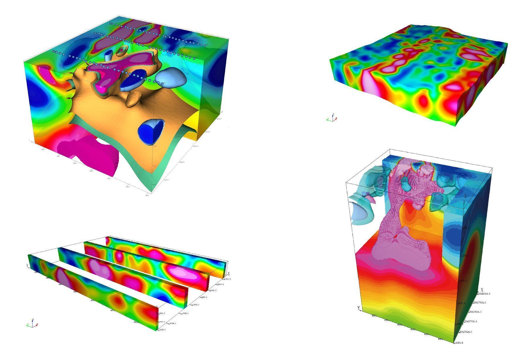
Classic 3D Geological Modeling – Horin® Classic 3D Geological Modeling allows the import of data from different formats and sources, such as geological maps, section geological maps, drilling information (such as survey, geological, and assay data), seismic section models, velocity voxel models, surface data (like terrain and remote sensing images), geophysical and geochemical data, 3D property voxel models from gravity, magnetic, and electrical inversions, 3D vector models, and more. It also enables the interpretation and modeling of 3D vector geological bodies and faults. The software allows for seamless integration, comparison, analysis, and export of original exploration data, inverse property models from gravity, magnetic, electrical, and seismic data, as well as intricate 3D geological models, all within a unified 3D environment.
Overview of Horin Geophysical Software Features
Gravity and Mag Correction
- Land – Designed to meet industry standards, aligned with user preferences, and easy to use.
- Aeromagnetic – The Horin® Aeromagnetic Module is tailored for processing magnetic data gathered from both UAV/drone and manned aircraft. While it retains many of the features of the marine magnetic module, it also includes additional capabilities designed specifically for airborne magnetic data. By consolidating the entire workflow within one software environment, it ensures smooth integration of all processing functions. This module guarantees results of the highest professionalism and quality.
Statistical Calculation of Magnetic Diurnal – Statistics of magnetic diurnal data, compression of diurnal file, matching and merging of diurnal stations.
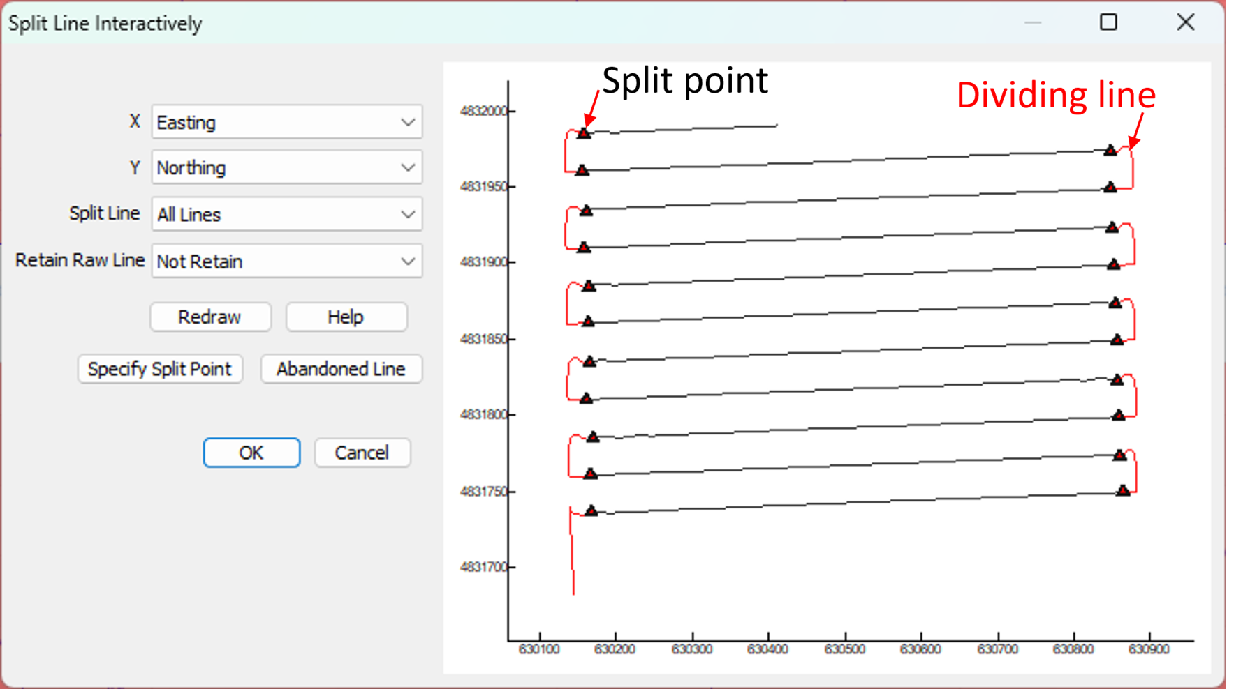
Aeromagnetic Exclusive Split Line Function – Split line by preset line, split line by polygon and interactive split line.
Statistical Function of Aeromagnetic – Includes statistics for flight duration, sampling rate configuration, static and dynamic noise levels, flight altitude, workload, yaw distance, and data acquisition system quality.
Lag Correction – This function addresses errors caused by positional discrepancies between GPS probes and the magnetometer, or time lags in GPS and magnetic data readings, preventing data reverse shifts in adjacent lines.
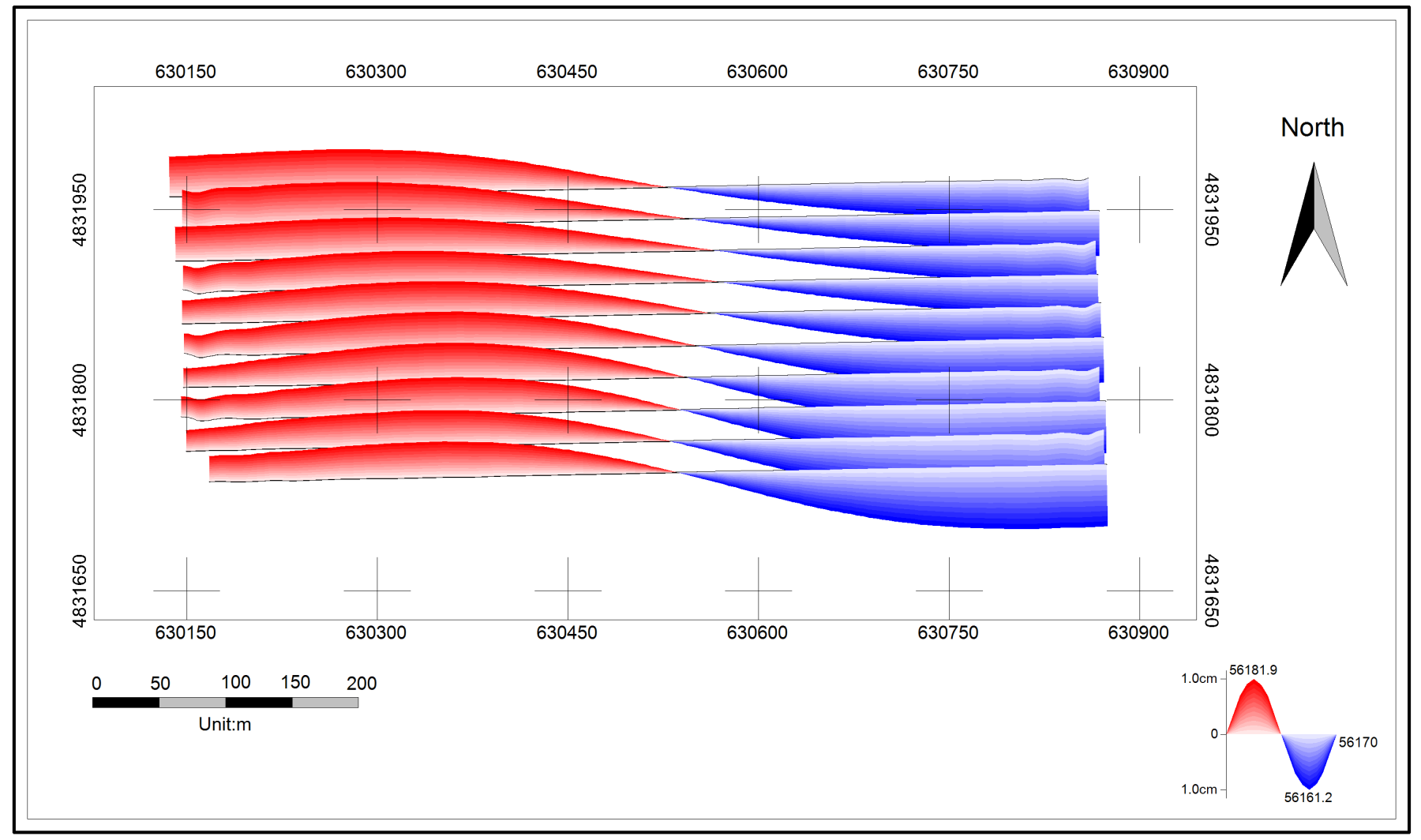
Heading Correction – This function corrects errors caused by variations in the heading of the survey platform, suitable for both airborne and marine magnetic survey data.
- Marine – Horin® software is the go-to professional tool for processing marine gravity and magnetic data, widely adopted within the industry. It is regarded as the leading software for marine gravity and magnetic data analysis.
Split Lines – It is possible to split line by reference column, by fiducial, by azimuth distance, by distance, by point spacing, by azimuth, by polygon, or by time.
Base Point Correction (Gravity) – Offers four functions: drift correction, correction of height and latitude differences at the base point, and conversion of the relative gravity value at the base point.
Eötvös Correction (Gravity) – In marine gravity surveys, the Eötvös effect is a significant source of error affecting survey accuracy. This function is optimized in three areas: track fitting, reasonable heading and speeding calculation, resulting in improved overall correction accuracy.
Terrain Correction (Gravity) – Enables terrain correction in the transitional zones where land meets sea.
Magnetic Disturbance Separation (Magnetic) – The program can efficiently identify days with magnetic disturbances, extract magnetic disturbance values from diurnal data using Fourier Series methods, and generate quiet day magnetic data, enhancing the accuracy of your magnetic corrections.
Marine Gravity and Magnetic Leveling – This feature includes system leveling and statistical leveling, allowing for the calculation of cross errors, their attributes, and mean square errors, as well as the generation of a statistical leveling table.
Potential Field Transformation and Filtering
Horin Software enables potential field transformations and filtering operations for gravity and magnetic data.
Euler 3D Inversion
Gravity and magnetic interpretation module features among other components Euler 3D inversion. It applies Euler deconvolution to reconstruct the 3D spatial distribution of the source, without needing prior data. This process enables fast determination of both the horizontal position and depth of the source body, allowing for efficient and reliable interpretation of gravity and magnetic data results.
Euler Solution Set – Using the analysis of observation data, the scale of geological structures is determined, followed by the definition of the search window size and the selection of the structural index based on predictions of potential geological formations. This allows for the rapid calculation of the 3D solution of the Euler field source, which is subsequently stored in the Horin database for future reference, including drawing and analysis. The Euler solution set is then displayed on a map. While the initial set of solutions may be extensive, it can be filtered using reliability indicators that are automatically generated, ensuring that only the most reliable 3D solutions are retained for further interpretation and analysis.
3D Gravity and Magnetic Forward and Inversion
Horin® Gravity and Magnetic 3D Forward and Inversion enables both individual and combined 3D forward modeling and inversion of gravity and magnetic data, starting from an initial geological model, for example, an implicit 3D geological model. By applying 3D inversion to gravity and magnetic data with the guidance of initial information, this method can incorporate known prior data or inversion constraints to extrapolate insights into areas lacking exploration data, based on the information available from explored regions. This approach helps minimize uncertainties in gravity and magnetic inversion, leading to more dependable inversion outcomes.
Method 1 for Creating the Initial Constraint Model: 3D Mesh Automatic Partitioning + Human-Comuter Interactive Polygon Interpolation for 3D Model Generation Across Multiple Cross-Sections + 3D Regular Model
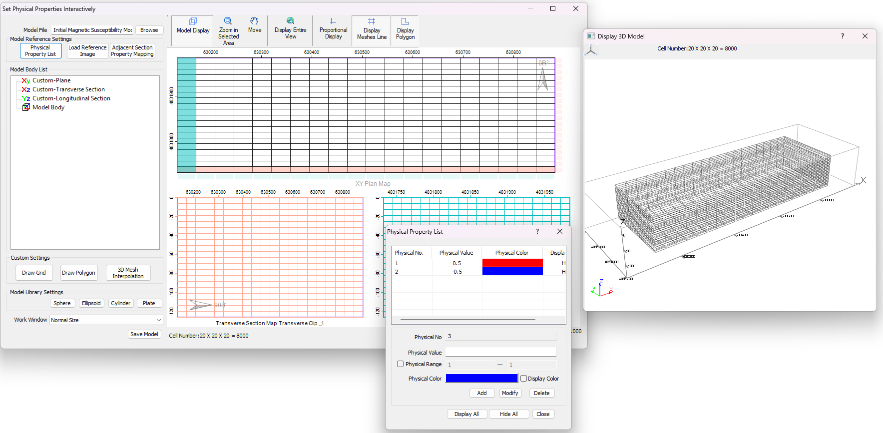
Horin Software gravity and magnetic 3D inversion creation module of initial allows for interactive inversion of various theoretical models, such as spheres, ellipsoids, plates, and cylinders. Besides, allows for the manual use of polygon tools to define model boundaries based on existing data, while incorporating 3D interpolation to generate 3D models. Each model can have its own set of average physical properties and distribution ranges, which enhances the accuracy of the inversion results.
Method 2 for Creating the Initial Constraint Model: Converting Complex Implicit 3D Geological Model to Initial Model
Horin Software enables the assignment of varying initial, minimum, and maximum values for density and magnetic susceptibility to the complex implicit 3D geological models created within the platform, based on different geological units. This acts as the initial model for the 3D forward and inversion of gravity and magnetic data. By integrating existing geological information, this initial model enhances the reliability of the gravity and magnetic 3D inversion performed with this initial constraint model.
Gravity and Magnetic 3D Forward and Inversion Calculation
The complete 3D voxel gravity and magnetic forward and inversion offer distinct advantages compared to 2D gravity and magnetic forward and inversion. One key benefit is the notable difference between the 2D constraints of the inversion data and the 3D constraints of the geological model data. This inherent multidimensional constraint helps to substantially minimize uncertainty in gravity and magnetic inversion, significantly improving the reliability of the results.
EM Data Processing & Interpretation
The EM module of Horin® Geophysical Software/Geoscience Software features EM Data Collation Tools and 2D, 3D MT Forward and Inversion. The EM Data Collation Tools encompass various features, including the import and export of data from different EM instruments, electrical spindle statistical analysis, impedance tensor rotation, tares processing, error bar drawing, quality control of survey line, data smoothness, creation of 3D geological constraint model, multiple section map drawing, multiple 3D map drawing and integrated map drawing, and more.
EM Data Import – Provided you are familiar with the structure of the original sampling data or the instrument's format, you can easily import the EM data into Horin® software. It supports various common data formats from EM instruments, including GMS-07, GDP32, V8, and more.
Impedance Tensor Decomposition – Carry out impedance tensor decomposition calculations for multiple points and frequencies, using rose diagrams for statistical analysis to determine the electrical spindle azimuth at various depths. After performing weighted statistics on the spindle azimuths at all depths, calculate the accurate electrical spindle azimuth for the survey area, and then perform the impedance rotation calculation.
Error Bar Display and Point Data Process Tool – Error bars for property values at multiple points can be plotted at the same time, offering a solid foundation for identifying tares. Horin Software's points data collation tool allows for batch editing and collating of multi-point data, while the software can automatically and interactively process tares through both automated and manual inputs.
2DMT – High Resolution Forward and Inversion – Incorporate the geological section map and drillhole data as constraints when creating the initial model to improve its reliability.
Horin Software’s 2D MT forward and inversion is both stable and reliable, delivering high-resolution inversion results while consuming minimal hardware resources. Most parameter settings automatically provide optimal default values, and after the calculation, the inversion results are automatically saved in a new database, which can be easily utilized for subsequent mapping and other tasks.
3DMT Forward and Inversion Calculation – The 3DMT forward and inversion module consists of two components: 3D geological model creation and 3D MT forward and inversion calculation. Geological maps and geological section maps can be used as references to build an initial 3D constrained geological model, which serves as the basis for performing 3D MT forward modeling. The module allows you to carry out 3D MT forward and inversion calculation on a large-scale 3D voxel model directly on your desktop computer, producing high-accuracy and high-resolution 3D inversion models within a few days to a week, depending on Horizontal Discretization.
Overview of Horin® Geoscience Software
Horin Implicit 3D Geological Modeling - Automated 3D Geological Modeling of Complex Structures
Features of Horin® lmplicit 3D Geological Modeling:
Multi-source Data Integration – The advanced 3D geological modeling capabilities enable constrained modeling using collected geological data, drilling information, and geological interpretation results from gravity, magnetic, electrical, and seismic data. This facilitates the creation of a detailed 3D geological model that corresponds with all exploration findings.
Advanced Modeling Algorithm – The sophisticated Co-Krige algorithm is capable of generating 3D geological models that follow stratigraphic sequences and feature complex structures, producing exceptionally clear and detailed three-dimensional models with greater consistency, logical coherence, and dependability.
Modeling Based on Rules – Horin's implicit modeling approach relies on stratigraphic sedimentary sequences, the interactions between faults, and the way faults intersect with strata. This method produces models that are more consistent with geological principles.
Through the analysis of the sedimentary environment and the relationships between stratigraphic layers, along with the historical fault activity, the shape and distribution of actual geological formations can be represented. Implicit modeling, using rules such as sedimentary sequences and fault-strata interactions, is capable of accurately simulating complex underground structures. It can reflect the continuity and variations in geological layers while effectively addressing multi-layered and multi-directional structural features.
Automated Modeling – This technology allows for the quick generation of highly detailed 3D geological models, greatly enhancing workflow efficiency and modeling results. Within a few hours, you can create complex and high-resolution 3D geological models, significantly boosting modeling effectiveness.
2D-3D Integration – By combining all map and section data, the 3D modeling process creates a flexible three-dimensional geological model that can be sliced to produce corresponding sectional geological models for visualization.
Coming Soon: Fully Automated Mining Borehole Analysis and 3D Modeling