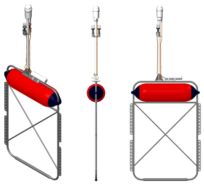
Front and tail buoys
Modern ultra-high resolution marine seismic surveys provide high-density spatial coverage with up to 0.5 m bin size. Such surveys require accurate positioning of the source-receiver spread to achieve desired resolution.
Front and tail buoys is a crucial part of 2D and 3D high-resolution marine seismic surveys, as they provide high accuracy control of streamer position, its towing depth and steering.
GEODEVICE manufactures robust and easy-to-use buoys, equipped with water-resistant multiband GNSS receivers with radio modems for wireless communication with onboard station.
GNSS receivers placed on front and tail buoys enable highly accurate hydrophone positioning with RTK or PPK modes, allowing for real-time coverage control.
The streamer fasteners, placed every 10 cm, keep the receiver cable at a pre-determined towing depth, allowing for the easy implementation of constant or slanted acquisition techniques using the buoys.
| Materials | Stainless steel and polymer |
| Dimensions | 1125×290×1590mm + 1000mm pole with GNSS receiver |
| Weight | 30 kg with GNSS receiver, battery and flashing lights |
| Satellite signals | GPS L1C/A, L2C; GLONASS L1OF, L2OF; Galileo E1B/C, E5b; BeiDou B1I, B2I; QZSS L1C/A, L1S, L2C |
| SBAS signal reception | WAAS, EGNOS, MSAS, GAGAN |
| Horizontal position accuracy | SBAS: 1 m RTK: 0.01 m + 1 ppm |
| Communication with onboard or onshore GNSS base station | 433 / 868 / 900 / 915 MHz and optional GSM modem for broadcasting RTK positioning and receiving corrections |
| RTK mode | rover, base or moving base |
| Radiolink range | up to 2 km or longer with larger antenna |
| Autonomy in radio mode | 5 days with 95Wh battery or longer with larger battery |
| RTK mode | rover |
| Connectors | USB |
| Wireless connection | Wi-Fi, Bluetooth |
| Offline position logging | track in txt and RAW GNSS data in RINEX with update rate up to 10 Hz |
| Memory | built-in microSD up to 32 GB |
| Flash light | yes |
| Operating temperature | -20 to +65 ºC |
| Power | 3.7 VDC |
| Battery | Li-ion, 3.7V, 95Wh |


